Suggested Answer:B🗳️
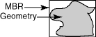
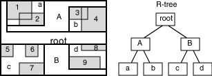
A spatial R-tree index can index spatial data of up to four dimensions. An R-tree index approximates each geometry by a single rectangle that minimally encloses the geometry (called the minimum bounding rectangle, or MBR), as shown in figure below. For a layer of geometries, an R-tree index consists of a hierarchical index on the MBRs of the geometries in the layer, as shown in the figure below. 1 through 9 are geometries in a layer. a, b, c, and d are the leaf nodes of the R-tree index, and contain minimum bounding rectangles of geometries, along with pointers to the geometries. For example, a contains the MBR of geometries 1 and 2, b contains the MBR of geometries 3 and 4, and so on. A contains the MBR of a and b, and B contains the MBR of c and d. The root contains the MBR of A and B (that is, the entire area shown). References: https://docs.oracle.com/cd/B28359_01/appdev.111/b28400/sdo_intro.htm#SPATL459
Currently there are no comments in this discussion, be the first to comment!
This section is not available anymore. Please use the main Exam Page.1z0-595 Exam Questions
Log in to ExamTopics
Sign in:
Community vote distribution
A (35%)
C (25%)
B (20%)
Other
Most Voted
A voting comment increases the vote count for the chosen answer by one.
Upvoting a comment with a selected answer will also increase the vote count towards that answer by one.
So if you see a comment that you already agree with, you can upvote it instead of posting a new comment.

Comments